Queensland Department of Agriculture and Fisheries (DAF)
Project
Queensland Department of Agriculture and Fisheries (DAF) Survey for Flinders and Gilbert Rivers Agricultural Resource Assessment
Location
Flinders and Gilbert Rivers – Queensland, Australia
Date
25th July 2018
QUEENSLAND DEPARTMENT OF AGRICULTURE
AND FISHERIES (DAF) SURVEY FOR FLINDERS
AND GILBERT RIVERS AGRICULTURAL
RESOURCE ASSESSMENT
Project Description Geo9 were invited to conduct this work as a technology demonstration project and compare the results of our 3D ground based Seismoelectric and electrotelluric surveying to 3D Skytem AEM data available from the CSIRO in this location. Geological reconnaissance was conducted and multiple areas surveyed that identified groundwater distribution and quality. Full report is available on request.
DETAILED PROJECT DESCRIPTION
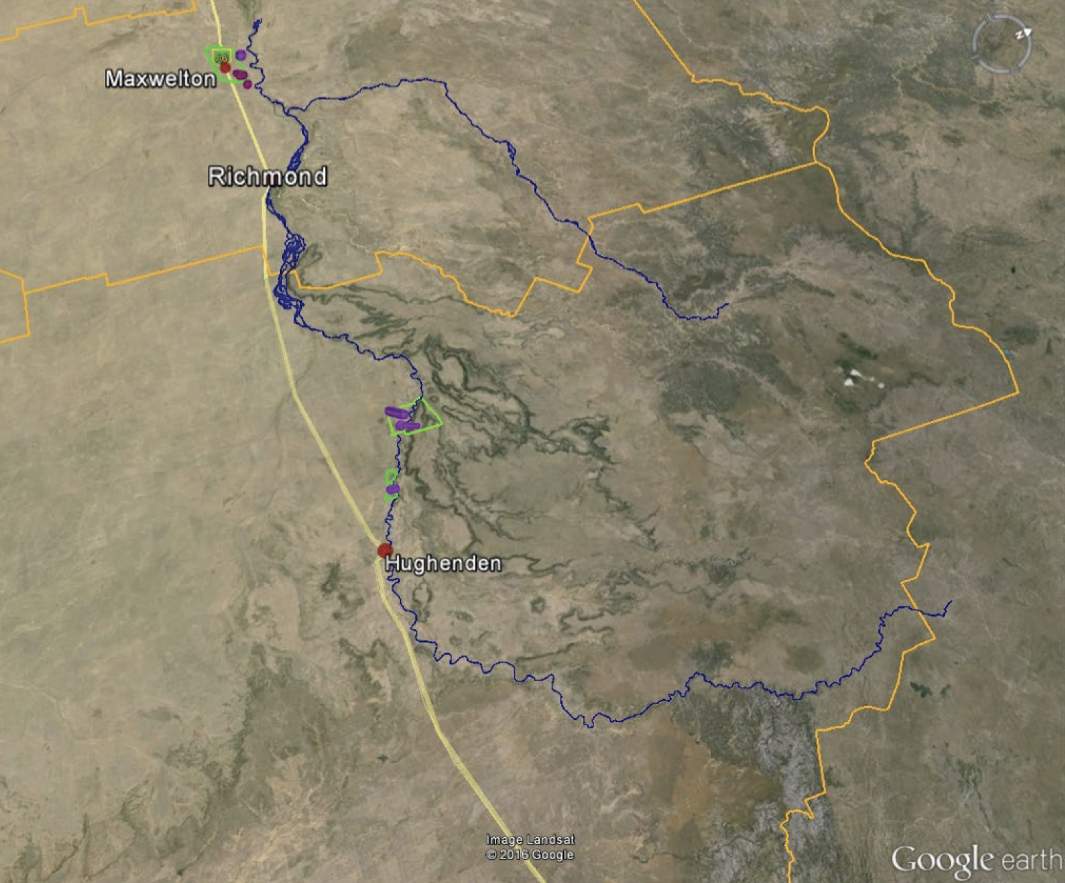
Surveying was conducted in four targeted locations in the catchment areas to support the objectives of the FGARA study. The project was conducted in three phases, with fieldwork starting at ‘Hopevale’ near Maxwelton, then ‘15 Mile’ and ‘Glendalough’ near Hughenden and concluding at ‘Majuba’, ‘Glendalough’ and ‘Hopevale’ in April 2016. The geological assessment and data interpretation was conducted by Geo9’s geologists and led by Paul Ferguson and Michael Cook. Fieldwork for the project was conducted over a period of approximately 20 days with state government officers, council officers and landholders all participating in the Geo9 surveys. Our work included a structural review of the region based on site observations, detailed geological reconnaissance and assessment of satellite imagery, airborne total magnetic intensity, radiometric and gravity data in additional to CSIRO’s AEM data. Geo9 also researched prior reports and developed conceptual site models to explain groundwater flow and recharge mechanisms at each survey location. The selected use of a 2D cross sections at ‘Glendalough’ and ‘Majuba’ provided an opportunity to directly correlate ground-based data with SkyTEM survey lines flown by CSIRO. The 2D cross section at ‘Glendalough’ was correlated to exploratory drilling conducted by the landowner and investigated the extent of the alluvial aquifer and its relationship to a broad depression identified in the regional total magnetic intensity image.
IMPACT OF THIS WORK
Geo9 has demonstrated that ground-based seismoelectric and electrotelluric surveying can be used cost-effectively for mapping groundwater resources at regional scale, and complements work conducted by government scientists. The Geo9 approach can be used to map aquifers, identify drilling targets and provide clarity on groundwater distribution and quality. New conceptual models for groundwater development were created by Geo9 and led to the identification of new areas of interest for groundwater exploration. This project delivered outcomes at considerably less cost and with considerable ease and speed relative to current methods used for hydrogeological investigation at this scale. The project also demonstrated the ability for multiple stakeholders to participate in a hands-on way with the collection of data that informs water management initiatives for the landholder and at all levels of government. Geo9 has provided detailed descriptions of groundwater flow paths, geological structure and groundwater distribution, and its likely availability from the new 3D geophysical models generated in the surveyed locations. The work has increased understanding of the recharge mechanisms at each site and generated groundwater drilling targets for a related aspect of CSIRO’s programme. Based on our geological reconnaissance at ‘Majuba’, Geo9 documented a large limestone nodule outcrop which was not previously mapped. Complemented by our understanding of the subsurface at that site from survey data, this knowledge offers a new opportunity for exploration of groundwater potential from a potential aquifer not previously identified.
Based on the model data, Geo9 inferred that groundwater recharge does not appear to be strongly driven by local infiltration, with the majority of recharge most likely occurring remote to the site. The low hydraulic conductivity observed in shallower zones (less than 140 metres below ground level) and the depth of the piezometric surface (at about 90 metres below ground level) was interpreted to indicate that the near surface is relatively dry with little surface recharge to groundwater locally. Geo9 concluded that, given the local arid climate and lack of apparent surface recharge, groundwater in the local system is likely to be ancient.